The last few years have seen some shifts in the 360º mobile mapping camera segment. The once ubiquitous Ladybug in its variations (3, 5, 5+) was once the norm for many companies collecting street-view imagery.
Mosaic brought to market the Mosaic 51 over 2 years ago and quickly made a splash with the addition of many valuable features, and a significant increase in resolution compared to the Ladybug5 (12k over 8k).
“The Mosaic 51 camera system should be the industry standard”
Dylan Faraone, Technical Director at Site Tour 360, a long-time user of 360º photography cameras recently reported.
This year (2022) saw the release and shipment of the global shutter variant of the Mosaic 51, named the Mosaic X. And in late 2022, Teledyne surprised some by announcing the release of the Ladybug6.
Looking for the technical breakdown? Skip to the bottom of the article.
(*Mosaic X is currently being shipped to customers around the world. Teledyne (FLIR), Ladybug producers, are quoting a 6+ month lead time.)
What Features are Important in a 360° Camera?
Let’s start by looking at what are the most valuable features of a 360º mobile mapping camera.
The main objective of a 360° mobile mapping camera is to accurately capture its surrounding space. The resolution needs to be high, and the images sharp, but not only that, but the camera should also be uncomplicated and user-friendly.
Let’s run through the list of ‘ideals’ that a 360° camera would have:
Resolution
Imagery quality here is key. The camera should have high resolution to capture the surroundings as accurately as possible. Ideally, when zooming in to view an object from a considerable distance, the objects in view should remain clear, and far away road signs, for example, should be clearly readable.
Usability A straightforward set-up and easy-to-use model – capturing imagery doesn’t need to be complicated. Ideally, you want to switch on and go and not have to worry about completing any tasks during data capture
GPS Connection
A must for a 360° camera unit. It will need to link efficiently to or have an in-built GPS to gauge location. This means combining data captured with accurate geo-referenced points.
Durability
All types of terrain will be photographed so it’s likely that your camera will see a multitude of different weathers. A camera system at the very least should be waterproof, dustproof, and able to withstand high and low temperatures. The casing itself should be hardwearing and the lens well protected against rouge pebbles or overhanging branches.
Easily Replaceable Parts
Mobile mapping cameras face a lot of wear and tear. One of the most common causes for pauses in the use of these cameras is when a lens gets scratched by a stray pebble. A minor scratch can cause weeks to months of delay in a project. Rather than replace a whole lens, a camera with replaceable lens covers means faster, cheaper repair and less time and energy wasted waiting.
Compact
As a 360° camera is an item expected to be well-traveled, a lightweight system is a requirement. A unit easily managed by one individual.
So, there we have the ‘musts and ideals’. Let’s compare two 360° camera systems, the Mosaic X with the Ladybug 6, and see who comes out on top.
Ladybug6 Camera
The new Ladybug6 is described as ideal for mobile mapping and all-weather inspection projects.
‘Ladybug6 cameras are engineered to deliver high-accuracy, high-resolution, and dependable results for applications such as HD mapping, asset management, roadside inspection, panoramic street image production for street view, road surveying, heritage scanning and building management.’
Teledyne (FLIR)
What the Ladybug6 Offers
The Ladybug6 supports frame rates of up to 29.9 FPS at 4K resolution and 15 FPS at 72 MP.
The Ladybug6 is hardwearing, an ‘all-metal’ system capable of operating in temperatures between -30 to 50°C, with a two-year warranty.
However, the literature does warn against exposing the Ladybug6 to extensive bright sunlight, rain, or dust.
Here we have some additional listed features:
- 72 Megapixel images with a spatial accuracy of +/- 2 mm at 10-meter distance
- Frame rates of up to 29.9 FPS at 4K resolution, 15 FPS at 72 MP
- IP65 rating with industrial-grade IP67-rated connectors
- Excellent color response, low noise, and a high dynamic range
- Captures, compresses and transmits 8-bit to12-bit pixel data
There is support for additional GNSS systems and trigger control via software with advanced API’s.
Drawbacks of the Ladybug6
Camera only
The Ladybug6 is a ‘camera only’ device, meaning it does not have any additional sensors, such as GPS or IMU, making it is necessary to have another device on board to capture timestamps.
Additional hardware requirements
The Ladybug6 (nor any of its predecessors) does not have the storage within the camera, necessitating a full workstation within the vehicle in order to operate and store the image data from the camera’s capture.
Due to the high demand for bandwidth during image capture, it is also important to consider the camera’s requirements with the capacity of your system.
Take a look here to see a breakdown of what is needed to connect the camera to an external system. This translates into more complications during the data capture, more manpower needed as well, and an increased chance of malfunctions during the process.
There is a development kit offered to support the Ladybug6 BUT it does need to be purchased separately.
Usability and Reliability
Due to the need for a large system in the vehicle, operating the Ladybug6 camera requires more work in set up and maintenance. It also lends itself to more points of failure.
Conclusion on the Ladybug6
The Ladybug6 is a decent camera with respectable image quality and resolution.
It’s a fairly robust system that can withstand impressive temperature extremes but this could not be for extended periods, such as long drives, and it does not appear to be fully waterproof or dust-resistant.
This is quite important for a mobile mapping camera, as the terrain can be unforgiving and the weather unexpected in various parts of the world.
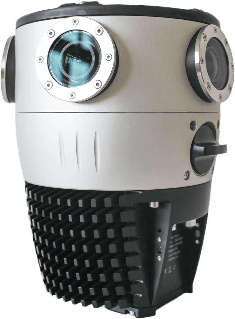
Mosaic X 360º camera system
The Mosaic X captures sharp imagery, is easy to use, and is an entirely independent standalone unit. Without touching on the finer details, this is already ticking some of the ideal requirements listed earlier.


What the Mosaic X Offers
Fully operating standalone camera system
The Mosaic X is a standalone camera system, complete with a CPU and GPU onboard for efficient controlling of the camera and storage of the data within a hot-swappable SSD. Additionally it has a built in GNSS and out puts all of the basic, but extremely necessary data needed in mobile mapping and surveying – including high resolution images, time stamps, and geographical coordinates.
Better, Clearer Vision
One of the leading benefits of the Mosaic X camera systems is that it offers sharp 13K vision. Ultra-crisp imagery is captured by the 360° lenses, the quality remains even in harsh sunlight. This means that even when inspecting details on roadside infrastructure such as road signs and street numbers at a considerable distance, these objects are rendered in excellent quality.
High-resolution imagery is important for many reasons, for accuracy, in the collection of data, to help asset recognition software better identify objects, and to ensure the data captured is right the first time around – reducing the need for repeated onsite visits and saving time for all parties involved.
Built-in GNSS Receiver
The Mosaic X, just like the Mosaic 51, comes with an internal (built-in) GPS device. This means that the camera does not necessarily need any additional GNSS device on the vehicle during data capture. Users can collect image data and geo-referenced points on the same drive, with no added work involved.
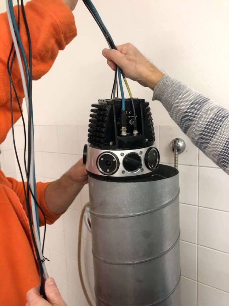
Compact Frame
The Mosaic X is a very compact unit, only one person is required to set it up and operate it. Being lightweight, it is easily fitted to a vehicle roof by a single person. Company personnel can be used more effectively as there is also minimal training required.
User-friendly Handling
The Mosaic X was designed to run for a typical day of data capture, without much (or any) need for extensive training.
- Hot-swappable 1 TB SSD storage grants a smoother transition between capture and usage.
- Simple but informative interface for simple operational tasks.
- Powered by a V-mount battery for consistent, reliable power during the ride.
Here we have several videos that explains just how straightforward the setup and usage are.
The resounding message here is that the Mosaic X is simple to install and simple to use.
Ability to Customize and Integrate
Should you wish, the camera can be personalized with additional sensors through an AUX port that can connect to other industry-standard devices. In this way, the camera can be customized to fit your needs.
Learn more about how the Mosaic X has already been integrated with one external GNSS device (Emlid Reach RS2+) and Riegl laser scanners in their two articles.
 Water testing – full submersion
 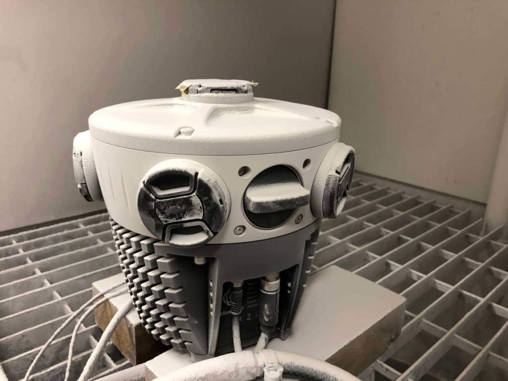 Climate testing
 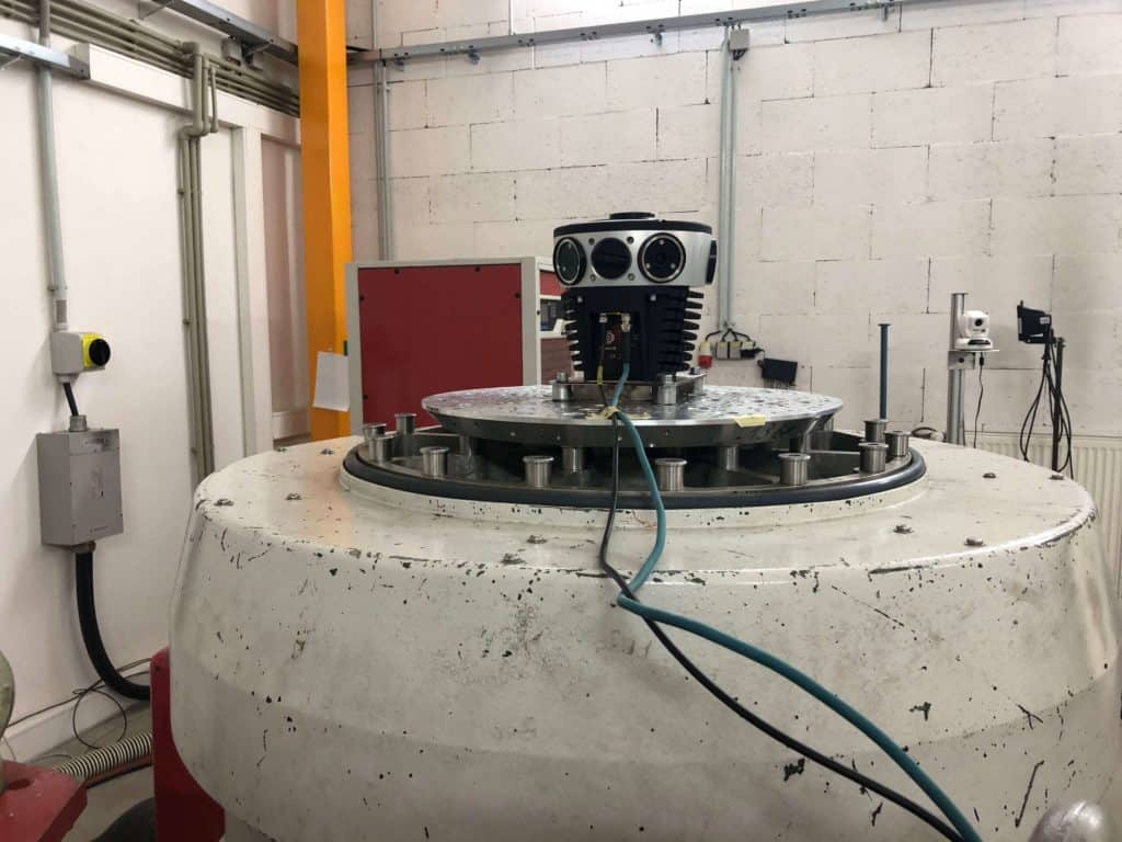 Vibration testing
 Robust and Reliable Structure
Like its brothers and sisters, (the Mosaic 51 and the Viking) the Mosaic X is just as hardy. Waterproof and dustproof, it can also withstand extremely high and low temperatures without affecting the quality of the imagery.
Non-vendor locked data
The Mosaic X does not lock users down or lock them into unnecessary software systems or data plans. The data is formatted so that it works with most industry-grade software solutions and can be easily formatted to meet the demands of the customer and the viewing capabilities of the end user. Whether 3rd party, in-house built, or open-source, the data is yours to use as you want.
Limited Downtime in Collection
Replaceable flat glass lens covers prevent expensive servicing of lenses. Easily and economically replace lens covers rather than requiring costly manufacture servicing.
Our Service
Notably, these features are important when comparing a 360° mobile mapping camera. The system itself, how it performs and user-friendliness are key components of a well-functioning system.
The company itself and the service provided is also something to consider. Should a lens cover be damaged on a Mosaic X, it can be easily replaced. This is considerably cheaper than having to ship the unit away for repairs if a lens itself is damaged, or in the very worst case, having to replace the unit altogether.
A reputable company with a knowledgeable team is incredibly useful, to get you set up correctly, answer any questions you may have, and bring to light questions you may not have thought of.
Drawbacks of the Mosaic X
The Mosaic X, unlike the various Ladybug models, does not come with proprietary software nor does it do any onboard stitching in realtime.
For some users, this is a negative. However, this means that customers of Mosaic X are able to choose the software of their choosing or use the original frames from the data capture, which is the best method when using photogrammetry software, such as when creating 3D models.
Conclusion on the Mosaic X camera system
The Mosaic X camera system is extreme versatile.
It can be run as a standalone unit, not requiring additional sensors or storage devices within the data capture vehicle.
It is also capable of integrating with external sensors to meet the demands of the user.
The non-vendor locked data means customers can work with whatever software system they wish – their own in-house solution or an external solution.
Technical Comparison Mosaic X vs Ladybug6
| Ladybug6 Camera | Mosaic X Camera System |
| Description of the system | 360° camera head + external post processing unit | Integrated 360° camera plug-and-play system |
| Additional device(s) needed for operation | High end Intel Core i7 computer with high end graphics card like HP Elitebook 830 G5 | Smartphone, tablet or laptop |
| Camera power and connectivity | 12-pin GPIO interface | Dedicated 4 pin power cable & separate GPIO interface |
| Power requirements | 13 Watt camera + ~60 Watt (computer)
= min. 73 Watt | 25 Watt camera + ~ 4 Watt (mobile phone) = min. 29 Watt |
| GNSS / GPS | External GNSS only | Built-in GNSS & ability to connect external GNSS for higher precision requirements |
| Data storage | Over USB cable streaming to in-computer RAID array or SSD | Camera built-in ultra fast SSD M.2 drive |
| Data transfer cable type / requirements | USB 3.1 Gen 1, PCIe ready modern computer | Industry standard CAT 5e RJ45 Ethernet cable, 1 GbE Ethernet port or any USB-C to Ethernet adapter |
| Data transfer cable length | 3 meters + need for active USB hub if longer | Almost no length constraint |
| Operating system | Microsoft Windows / Linux on x86 & x86-64 | Platform independent, standard web browser on any platform or even command line for REST API |
| API type | Proprietary via Ladybug SDK | Standardized REST API (OpenAPI Specification) |
| Software requirements for image capture | Ladybug SDK | None (image capturing software is built into the camera) |
| Software requirements for post processing | Ladybug SDK, Microsoft Visual Studio & g++ | Non-vendor locked data = any software of your choosing |
| Firmware upgrades | Via Ladybug SDK | One-click web browser OTA update |
| Video streaming capability | Over USB 3.1 | Over Gigabit Ethernet |
| Primary data output format | Proprietary PGR stream file format | Open MP4 digital multimedia container format, CSV, JSON, GPX open format for GNSS data & metadata |
Conclusion
Multiple sectors need high-quality imagery to capture data. Governments, surveyors, local municipalities, telecoms, and energy providers. The list is endless. 360° capture is not only used for mobile mapping, but for photogrammetry in the medical field, for architects when designing space, and for artists.
The ideal mobile mapping system should encompass the features listed above because the system is a full package and not just a means for capturing data. Having the best equipment for a project or survey will lead to a more streamlined and efficient work process. This will save time down the line by reducing delays and reducing the need for repeated site visits as mentioned.
In conclusion, the Ladybug6 is a respectable 360° camera that will do as it is tasked. It will capture data, however, it is not so user-friendly due to the additional software required. This will take further reading, comprehension, and additional time which instead could be used for getting the job done.
But if you want exemplary results in the form of high-quality, high-resolution imagery from a standalone unit, that is compact, easy to use, and durable in extreme weather- when comparing two 360° cameras, the Mosaic X is the clear winner.
Get in touch with us to find out more about the Mosaic X, let us answer any questions you may have, and for more information and detailed specifications follow this link.